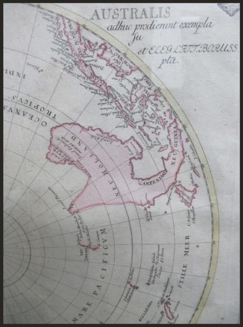
ANTARCTIC: 1753 'Tabula Geographica Hemisphaerii Australis' (= Southern Hemisphere) circular map by Johann Christoph Rhode [published by Leonard Euler, Berlin] being an unusual projection from the imagined South Pole (truly Terra Nullius) to the southern parts of Africa, South America & Australia with Tasmania & New Guinea shown as part of a contiguous landmass, window mounted, framed & glazed, overall 56x56cm. [The Australian coastline is based on the discoveries made by Abel Tasman on his two voyages 1642-44. No significant further mapping occurred until 1770 when James Cook charted the East Coast of the continent] (Image1)
Estimate AU$450
Opening AU$ 340.00
Sold...AU$ 340.00
Closed..Nov-11-2022, 18:00:00 EST
Sold For 340
Sale No: 249
Lot No: 3610
Symbol: D
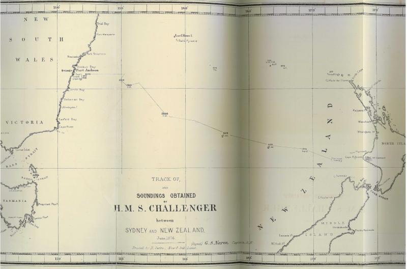
AUSTRALIA - NEW SOUTH WALES: 1875 black & white maps (550x345mm) traced by H Swire, Naval Sub-Lieut and signed by GS Nares, Captain RN showing the track and soundings obtained by HMS Challenger between Sydney and Wellington and mapping the coastlines of New South Wales, Victoria, Tasmania and the New Zealand North Island & Middle Island (now South Island), attached to an 1875 report to NSW (& later NZ) Governor Sir Hercules Robinson, minor edge faults & a couple of closed tears repaired with archival tape, a couple of tiny aging marks otherwise fine. [Captain George Nares of HMS Challenger led a circumnavigation of the globe between 1872-1876 - which became known as the 'Challenger Expedition' - conducting a scientific program that laid the foundation of oceanography as well as discovering more than 4700 new species of marine life] (Image1)
Estimate AU$400
Opening AU$ 300.00
Sold...AU$ 300.00
Closed..Nov-11-2022, 18:00:00 EST
Sold For 300
Sale No: 249
Lot No: 3611
Symbol: D
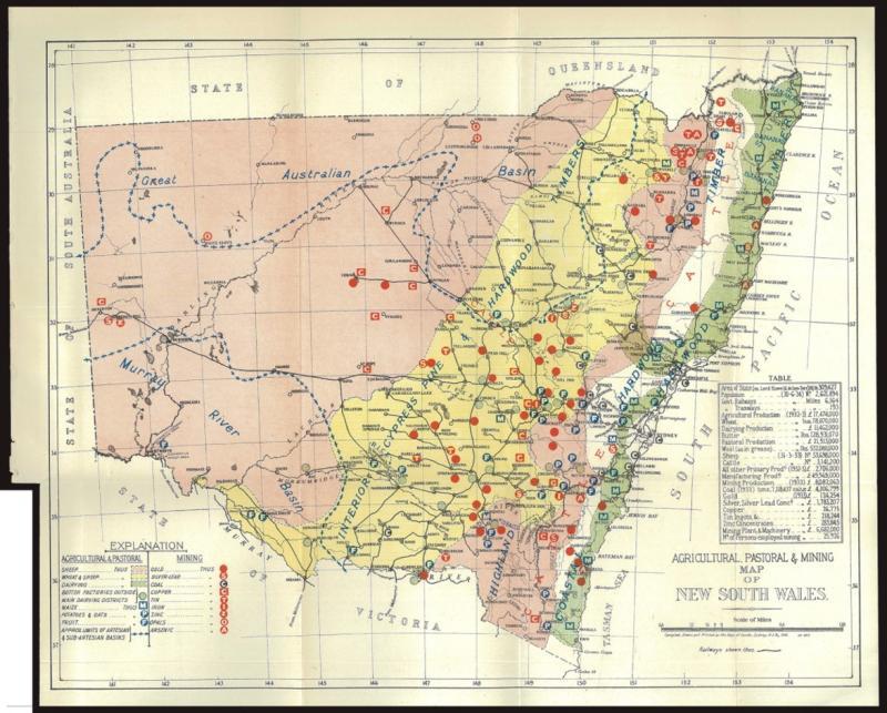
AUSTRALIA - NEW SOUTH WALES: 1934 multi-coloured map (300x250mm) compiled, drawn & printed by NSW Department of Lands, with agricultural, pastoral & mining areas identified, also artesian basins, railways and a table of production statistics, folded as issued, tiny closed tear at left (repaired with archival tape). (Image1)
Estimate AU$100
Opening AU$ 75.00
Sold...AU$ 75.00
Closed..Nov-11-2022, 18:00:00 EST
Sold For 75
Sale No: 249
Lot No: 3612
Symbol: D
Cat No: Collection
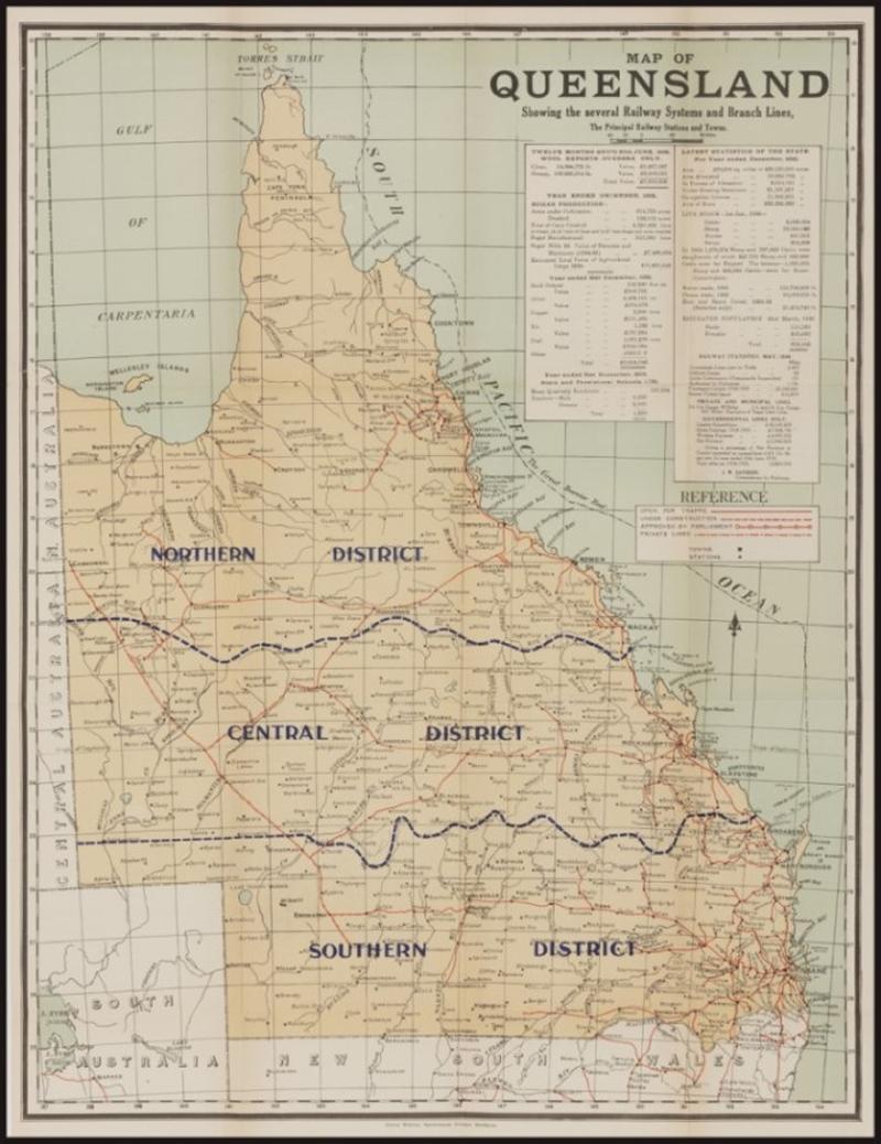
AUSTRALIA - QUEENSLAND: 1936 multi-coloured map (570x433mm) printed by David Whyte, Government Printer, Brisbane showing also small parts of North Australia, Central Australia, South Australia (to Lake Eyre) and New South Wales, includes district boundaries, railways & railway stations and two tables of argicultural & mining production and population, livestock & railway statistics, folded as issued, small 6cm closed tear at left (repaired with archival tape) and a couple of minor blemishes. (Image1)
Estimate AU$100
Opening AU$ 75.00
Sold...AU$ 75.00
Closed..Nov-11-2022, 18:00:00 EST
Sold For 75
Sale No: 249
Lot No: 3613
Symbol: D
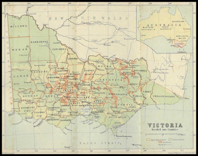
AUSTRALIA - VICTORIA: 1870s (circa) multicoloured map (210x290mm) published by EG Ravenstein and printed by George Philip & Son, London & Liverpool showing county names & boundaries, railways, auriferous (gold) regions and agricultural & pastoral land, folded as issued with some aging/spotting marks. [Note that the 'town' of Westbury, Gippsland is given prominence (a rural community that never had a Post Office) but that there is no mention of Mildura, Edenhope, Cunninghame (Lakes Entrance) nor Orbost] (Image1)
Estimate AU$100
Opening AU$ 75.00
Sold...AU$ 75.00
Closed..Nov-11-2022, 18:00:00 EST
Sold For 75
Sale No: 249
Lot No: 3614
Symbol:
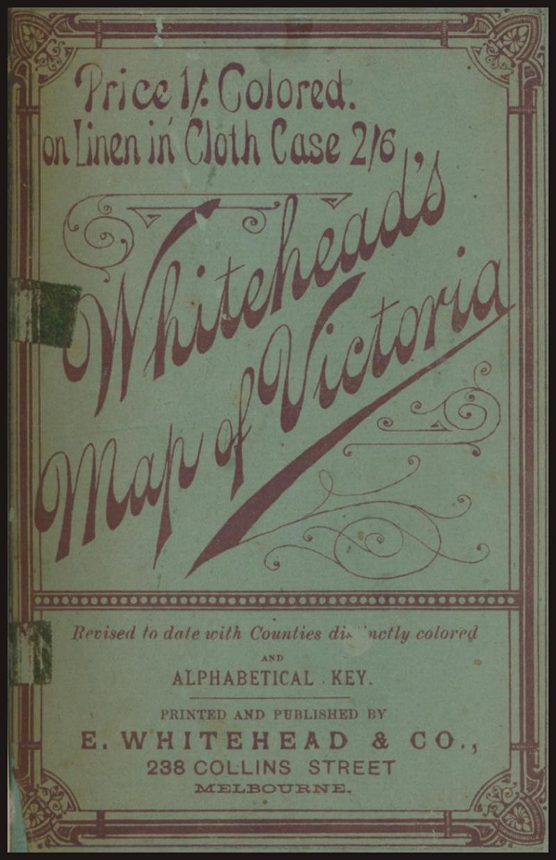
AUSTRALIA - VICTORIA: 'E Whithead & Co.'s Map of Victoria' [Melbourne, 1896] with Alphabetical Key, 28pp, rebound in cloth covers with title on spine, contents includes 'Short Tours for Cyclists from Melbourne', and Rates of Postage. Map with some foxing and tape repairs along folds, size 63x51cm, Fair condition. (Image1)
Estimate AU$100
Opening AU$ 75.00
Sold...AU$ 75.00
Closed..Nov-11-2022, 18:00:00 EST
Sold For 75
Sale No: 249
Lot No: 3615
Symbol: D
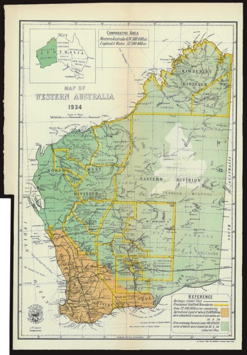
AUSTRALIA - WESTERN AUSTRALIA: 1934 multi-coloured map (366x240mm) published by JP Camm, Surveyor-General, Department of Lands & Surveys and printed by authority of Fred Wm Simpson, Government Printer, Perth, includes railways, proclaimed goldfields boundaries, the telegraphic 'Cable from Cocos Is & Sth Africa' and shipping connections, folded as issued, tiny closed tear at left (repaired with archival tape) otherwise fine. (Image1)
Estimate AU$100
Opening AU$ 260.00
Sold...AU$ 260.00
Closed..Nov-11-2022, 18:00:00 EST
Sold For 260
Sale No: 249
Lot No: 3616
Symbol: D
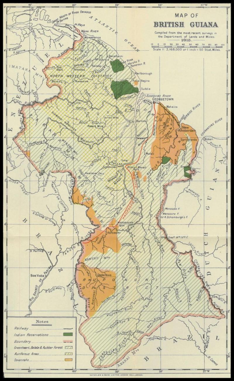
BRITISH GUIANA: 1915 multicoloured map (340x202mm) printed by Waterlow & Sons, London Wall including as well small parts of surrounding Brazil, Venezuela & Dutch Guiana, showing railways, forests & savannahs, auriferous (gold) areas and 'Indian Reservations', folded as issued, a couple of minor blemishes in the margins otherwise very fine. (Image1)
Estimate AU$100
Opening AU$ 75.00
Sold...AU$ 75.00
Closed..Nov-11-2022, 18:00:00 EST
Sold For 75
Sale No: 249
Lot No: 3617
Symbol: D
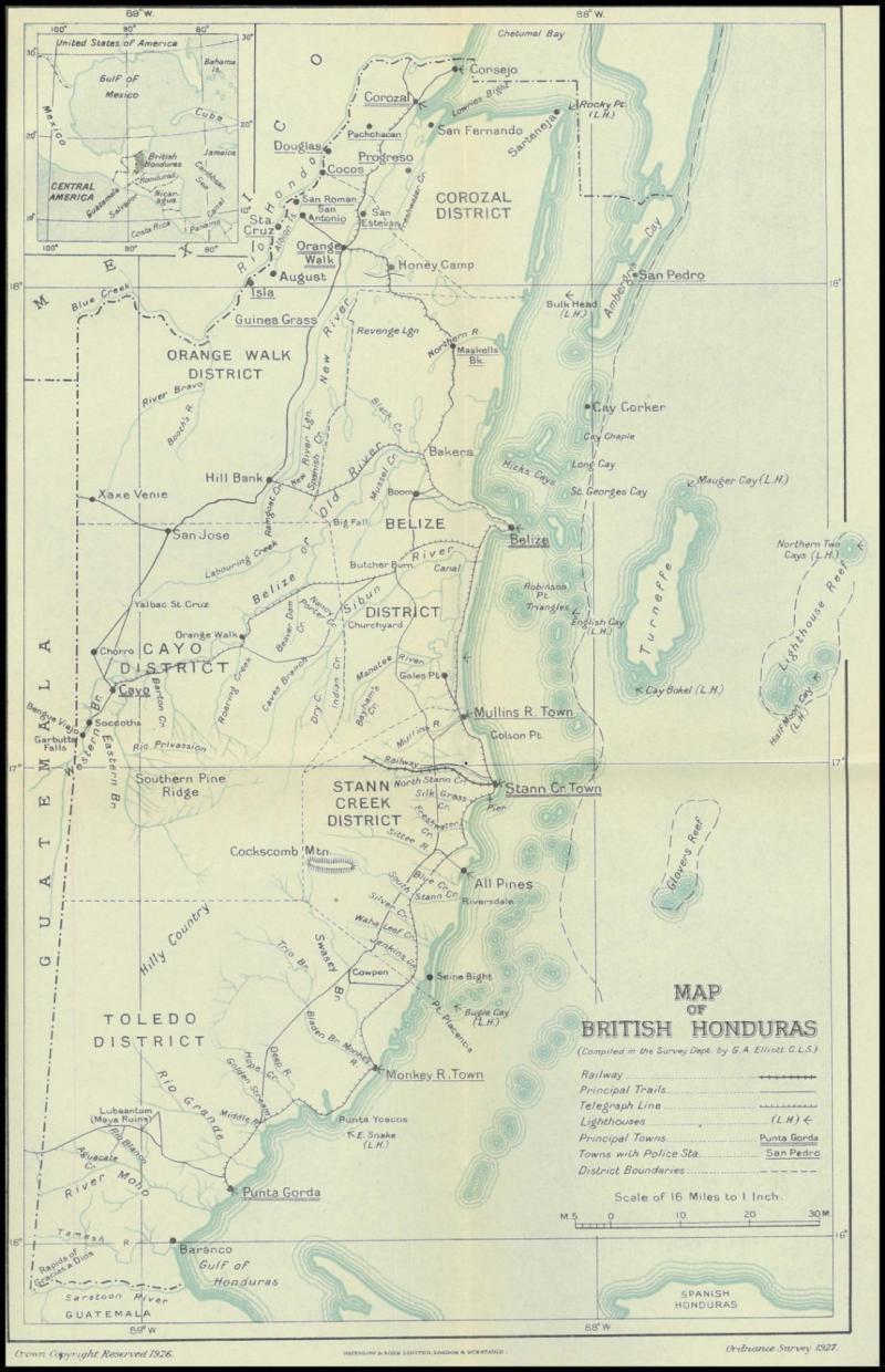
BRITISH HONDURAS: 1926 black, light blue & white map (340x210mm) published by the Ordnance Survey and printed by Waterlow & Sons, London & Dunstable showing district boundaries, principal trails & railways, lighthouses and police stations, includes an inset map of the countries around the Gulf of Mexico, folded as issued, very fine condition. (Image1)
Estimate AU$100
Opening AU$ 75.00
Sold...AU$ 75.00
Closed..Nov-11-2022, 18:00:00 EST
Sold For 75
Sale No: 249
Lot No: 3618
Symbol: D
Cat No: Collection
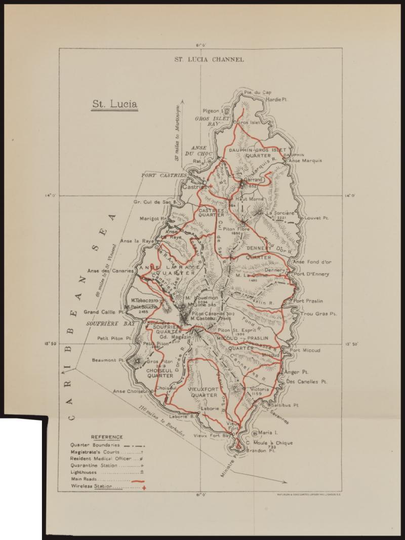
BRITISH EMPIRE: Group of 1880s-1930s maps ranging in size from 135x210mm up to 410x440mm comprising Barbados, Bermudas, British Honduras, Cyprus, Falkland Islands, Gambia, Lagos, Mauritius, Montserrat, Natal (2), Seychelles, St Lucia, Tobago, Trinidad (2) and Turks & Caicos Islands, the larger maps folded as issued, a few with minor faults but the condition is generally fine to very fine.
(17) (Image1)
Estimate AU$400
Opening AU$ 300.00
Sold...AU$ 300.00
Closed..Nov-11-2022, 18:00:00 EST
Sold For 300
Sale No: 249
Lot No: 3619
Symbol: D
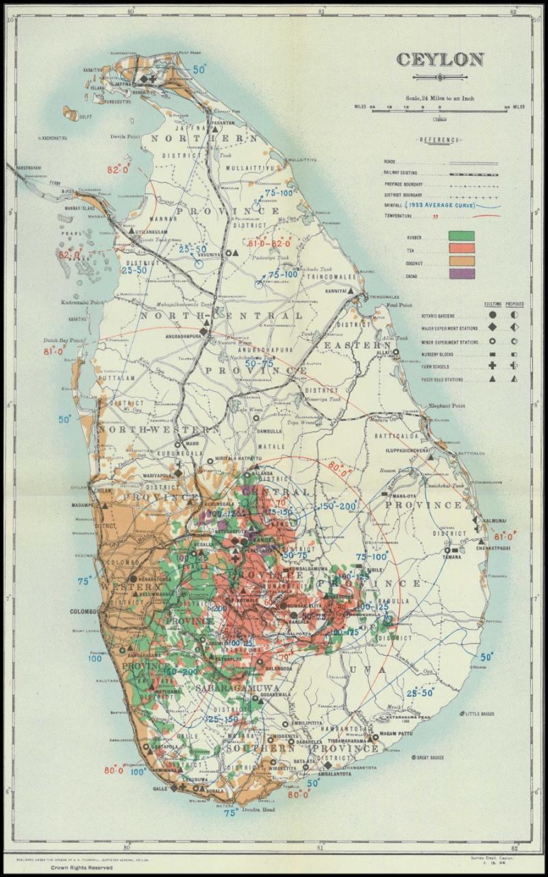
CEYLON: 1934 multicoloured map (353x217mm) published by GK Thornhill, Surveyor General, Survey Department showing provincial & district boundaries, railways & main roads, rainfall & temperature, production of rubber, tea, coconut & cacao and other agriculture, folded as issued with a couple of very minor edge bends in the margin otherwise very fine condition. (Image1)
Estimate AU$100
Opening AU$ 75.00
Sold...AU$ 75.00
Closed..Nov-11-2022, 18:00:00 EST
Sold For 75
Sale No: 249
Lot No: 3620
Symbol: D
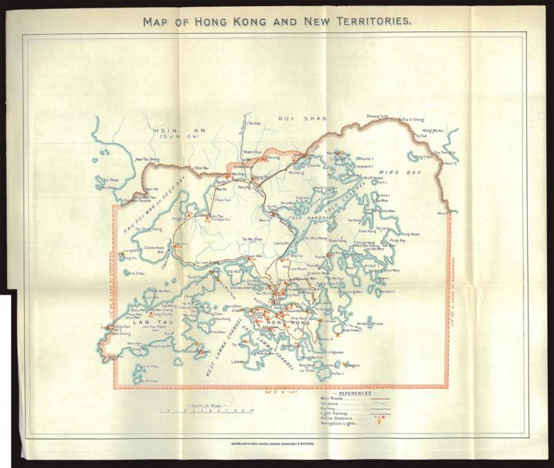
CHINA - HONG KONG: 1930 (circa) outline-coloured map (333x390mm) of 'Hong Kong and New Territories' printed by Waterlow & Sons, London, Dunstable & Watford including roads, railways, police stations and navigation lights, folded as issued, a couple of tiny blemishes in the margins otherwise very fine. [The inclusion of 'Watford' in the printer's inscription dates the map to about 1930, before its Milton Street, Watford operations were closed after the Bank of England in 1928 took over printing banknotes which had until then been printed by Waterlow under contract to the Treasury. A 2016 English dealer's pricelist offered an example with small tear for £600] (Image1)
Estimate AU$400
Opening AU$ 300.00
Sold...AU$ 300.00
Closed..Nov-11-2022, 18:00:00 EST
Sold For 300
Sale No: 249
Lot No: 3621
Symbol: D
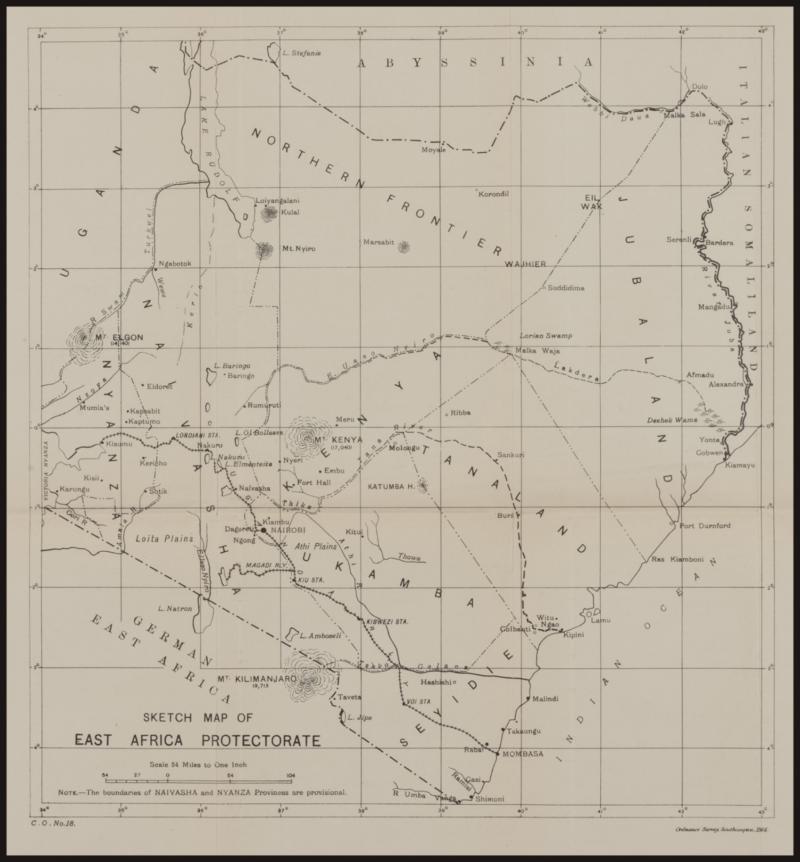
EAST AFRICA PROTECTORATE: 1914 black & white sketch map (415x390mm) published by the Ordnance Survey, Southampton including the provinces of Nyanza, Naivasha, Kenya, Ukamba, Seyidie, Tanaland, Jubaland (ceded to Italy in 1925) & the Northern Frontier as well as parts of surrounding Uganda, Abyssinia, Italian Somaliland & German East Africa, showing boundaries (those of Nyanza & Naivasha stated to be 'provisional') and the Mombasa-Kisumu and Magadi railways, folded as issued with a few additional folds and minor blemishes in the margins otherwise very fine. (Image1)
Estimate AU$100
Opening AU$ 75.00
Sold...AU$ 75.00
Closed..Nov-11-2022, 18:00:00 EST
Sold For 75
Sale No: 249
Lot No: 3622
Symbol: D
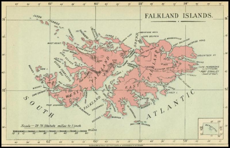
FALKLAND ISLANDS: 1920s (circa) black, blue & pink map (140x215mm) printed by Waterlow & Sons, London, Dunstable & Watford with an inset map of Beauchene Island at lower right, a couple of very minor edge bends in the margin otherwise very fine condition. (Image1)
Estimate AU$100
Opening AU$ 75.00
Sold...AU$ 75.00
Closed..Nov-11-2022, 18:00:00 EST
Sold For 75
Sale No: 249
Lot No: 3623
Symbol: D
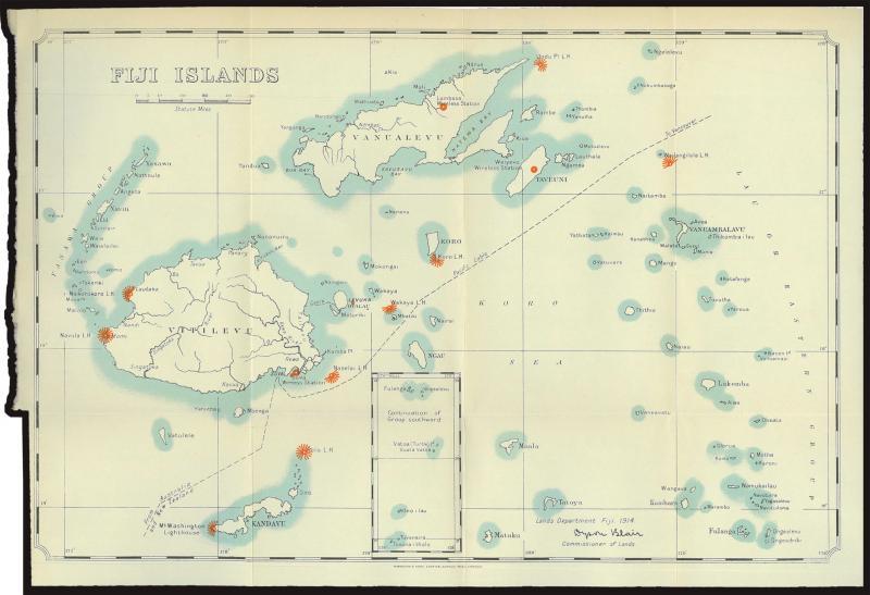
FIJI: 1914 black, light blue, red & white map (274x399mm) published by Dyson Blair, Commissioner of Lands, Lands Department, Fiji and printed by Waterlow & Sons, London Wall, London showing the area from Vitilevu in the west, Vanualevu in the north, Lakemba in the east and Matuku in the south with an inset map of the further southern islands to Tuvanaitholo but not Rotuma to the north, folded as issued. (Image1)
Estimate AU$100
Opening AU$ 75.00
Sold...AU$ 75.00
Closed..Nov-11-2022, 18:00:00 EST
Sold For 75
Sale No: 249
Lot No: 3624
Symbol: D
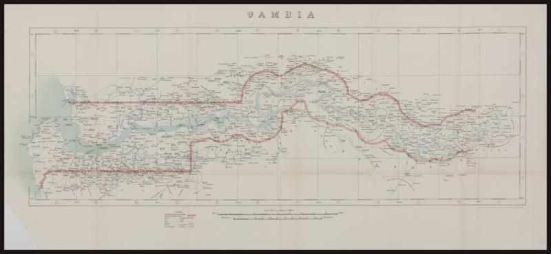
GAMBIA: 1912 black, blue & red map (335x730mm) printed by the Ordnance Survey Office, Southampton including parts of surrounding areas of Nium-Bato, Rip, Diamma, Niani, Kantora, Fuladuga, Ferdu, Jarra, Jalaba, Kabada & Foni, showing the length of the River Gambia to Genoto in the east with international boundaries & boundary pillars (the eastern boundary not yet finally determined), creeks, rivers & marshes and wharfs, the town names given in Mandinga, Yolof & Fula languages, folded as issued with a couple of minor closed tears in the folds, a couple of minor folds in the margins and the L/L corner margin trimmed (not affecting the printed area). (Image1)
Estimate AU$100
Opening AU$ 75.00
Sold...AU$ 75.00
Closed..Nov-11-2022, 18:00:00 EST
Sold For 75
Sale No: 249
Lot No: 3625
Symbol: D
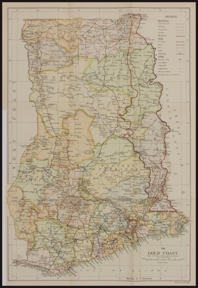
GOLD COAST: 1934 multicoloured map (510x340mm) 'with Togoland under British Mandate' published by the Survey HQ, Accra showing international, colonial, provincial & district boundaries, roads & railways, post & telegraph offices, lighthouses, wireless stations and preventive service stations, folded as issued with a couple of minor blemishes in the margins otherwise very fine. (Image1)
Estimate AU$100
Opening AU$ 75.00
Sold...AU$ 75.00
Closed..Nov-11-2022, 18:00:00 EST
Sold For 75
Sale No: 249
Lot No: 3626
Symbol: D
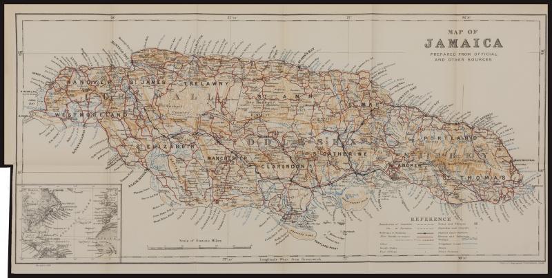
JAMAICA: 1935 multicoloured map (320x630mm) published by Stanford's Geographical Establishment, London showing county & parish boundaries, roads & bridle paths, railways & railway stations, post offices, churches & chapels, rivers & irrigation canals and police stations, folded as issued, very fine condition. (Image1)
Estimate AU$100
Opening AU$ 75.00
Sold...AU$ 75.00
Closed..Nov-11-2022, 18:00:00 EST
Sold For 75
Sale No: 249
Lot No: 3627
Symbol: D
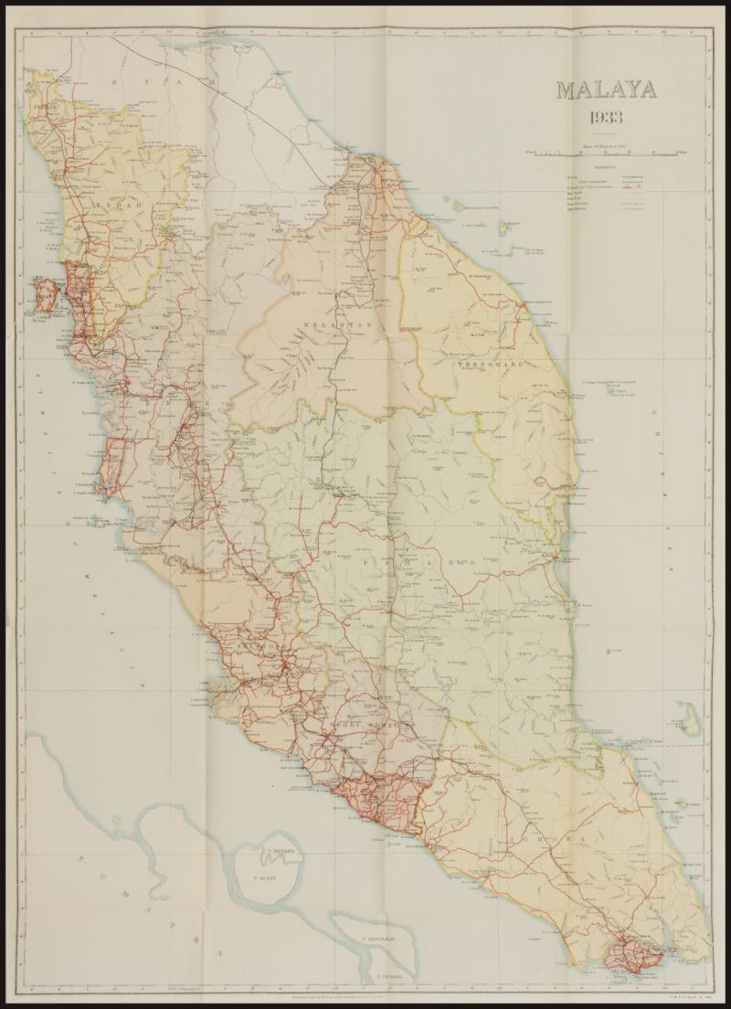
MALAYA: 1933 multi-coloured map (580x420mm) on thin paper 'Published under the direction of the Surveyor General of FMS & SS' [Federated Malay States & Straits Settlements] showing the entire Malayan peninsula from Perlis in the north to Penang in the west and Singapore in the south including railways, roads, cart tracks [!] & footpaths, folded as issued, a couple of tiny closed tears in the folds. [A similar map dated 1930 is currently being offered by a California map dealer for US$750; see also next Lot] (Image1)
Estimate AU$300
Opening AU$ 230.00
Sold...AU$ 230.00
Closed..Nov-11-2022, 18:00:00 EST
Sold For 230
Sale No: 249
Lot No: 3628
Symbol: D
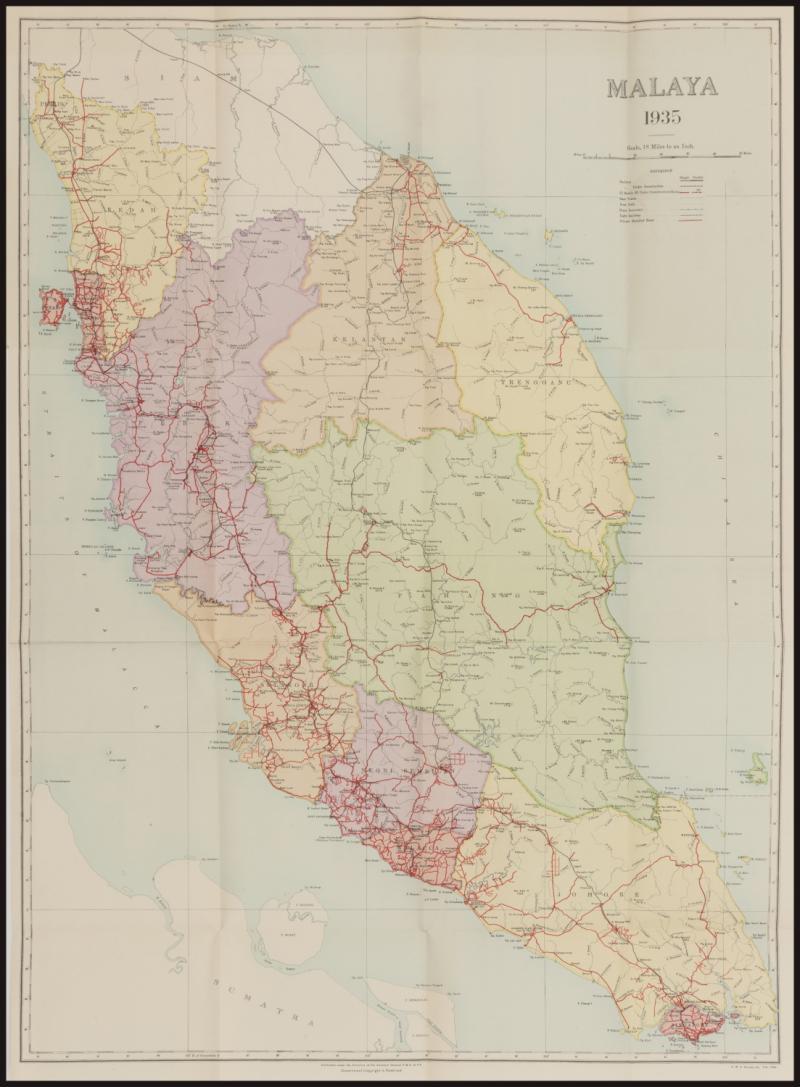
MALAYA: 1935 multi-coloured map (580x420mm) on thick paper 'Published under the direction of the Surveyor General of FMS & SS' [Federated Malay States & Straits Settlements] showing the entire Malayan peninsula from Perlis in the north to Penang in the west and Singapore in the south including railways, roads, cart tracks [!], footpaths & 'private metalled roads', folded as issued. [A similar map dated 1930 is currently being offered by a California map dealer for US$750; see also previous Lot for the 1933 edition of this map, from which this differs quite substantially including by the addition of 'private metalled roads' and by addition of town names & changes in the spelling of others] (Image1)
Estimate AU$300
Opening AU$ 230.00
Sold...AU$ 230.00
Closed..Nov-11-2022, 18:00:00 EST
Sold For 230
Sale No: 249
Lot No: 3629
Symbol: D
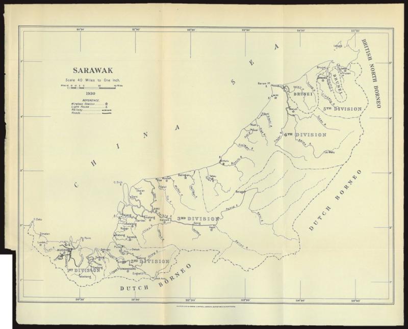
MALAYA - SARAWAK: 1930 sketch map (257x318mm) printed by Waterlow & Sons, London, Dunstable & Watford showing also Brunei & Labuan as well as small parts of surrounding British North Borneo & Dutch Borneo, includes divisional boundaries, roads, railways, wireless stations and lighthouses, folded as issued, a couple of minor creases at left mostly in the margins otherwise very fine. (Image1)
Estimate AU$100
Opening AU$ 75.00
Sold...AU$ 75.00
Closed..Nov-11-2022, 18:00:00 EST
Sold For 75
Sale No: 249
Lot No: 3630
Symbol: D
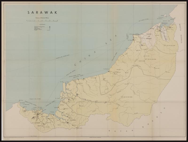
MALAYA - SARAWAK: 1949 multi-coloured map (463x620mm) drawn by the Directorate of Colonial Surveys showing also Brunei & Labuan as well as small parts of surrounding North Borneo & Dutch Borneo, includes divisional boundaries & headquarters, roads, wireless stations and distances by sea between the major towns and to Singapore, folded as issued, a couple of minor creases in the left-hand margin otherwise very fine. (Image1)
Estimate AU$100
Opening AU$ 75.00
Sold...AU$ 75.00
Closed..Nov-11-2022, 18:00:00 EST
Sold For 75
Sale No: 249
Lot No: 3631
Symbol: D
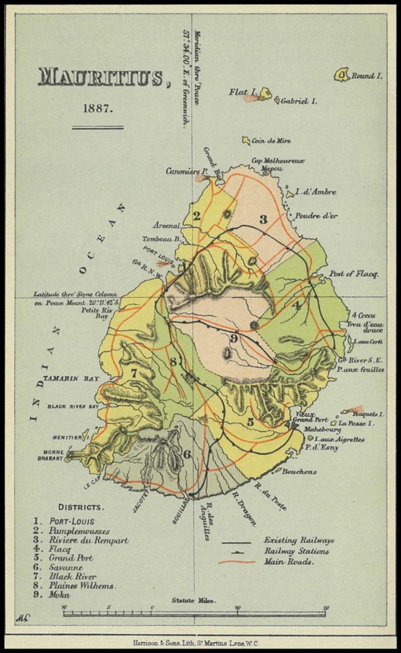
MAURITIUS: 1887 multicoloured map (212x136mm) printed by Harrison & Sons, London showing district boundaries, railways & railway stations and main roads, a couple of very minor edge bends in the margin otherwise very fine condition. (Image1)
Estimate AU$100
Opening AU$ 75.00
Sold...AU$ 75.00
Closed..Nov-11-2022, 18:00:00 EST
Sold For 75
Sale No: 249
Lot No: 3632
Symbol:
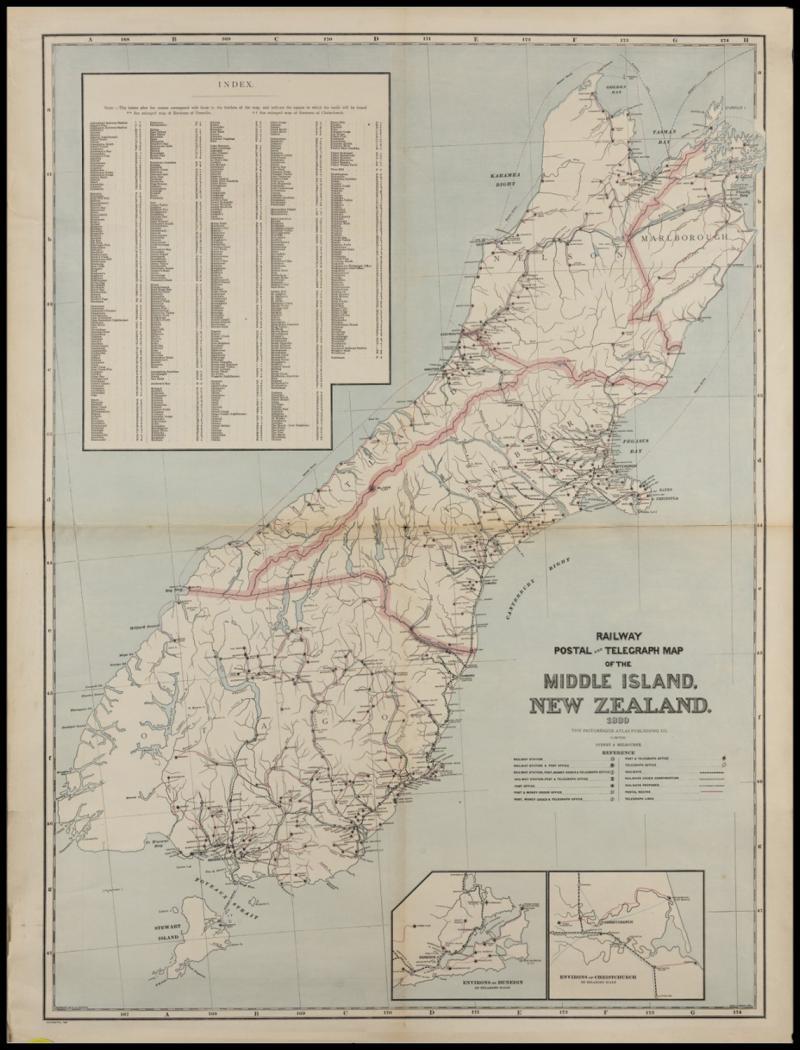
NEW ZEALAND: 1889 Pictureque Atlas Publishing Company Railway Postal & Telegraph Maps of the North Island and of the South Island(both 850X670mm) referring to the South Island as the 'Middle Island' with Stewart Island to the south, each including a complete list of Post & Telegraph Offices along with an index of where they are located plus inset maps of Auckland, or of Dunedin & Christchurch, showing district boundaries, types of offices, railways including under construction & proposed, telegraph lines and postal routes, both folded as issued, mostly small tears along folds repaired with archival tape, minor overall aging. [At this time, the South Island was commonly referred to 'Middle' Island, and Stewart Island as 'South' Island. In 1907, the government directed that the larger island be called 'South' Island "in all cases"]
(2) (Image1)
Estimate AU$200
Opening AU$ 150.00
Sold...AU$ 150.00
Closed..Nov-11-2022, 18:00:00 EST
Sold For 150
Sale No: 249
Lot No: 3633
Symbol:
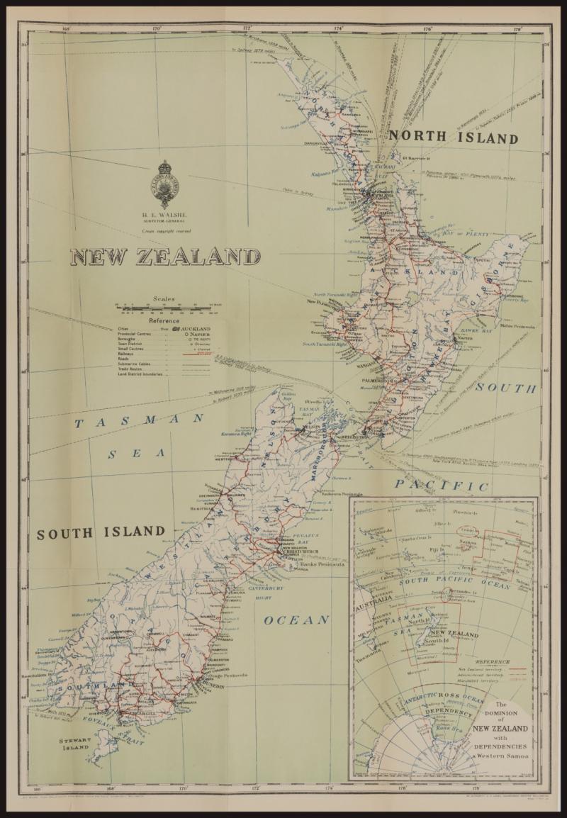
NEW ZEALAND: 1934 multi-coloured map (528x358mm) drawn by AL Wicks, Chief Draughtsman and published by HE Walsh, Surveyor-General, NZ Lands & Survey showing the North & South Islands, Stewart Island and an inset map of New Zealand's position in relation to the Antarctic with Ross Dependency, Australia and the Pacific Islands, includes district boundaries, railways, roads, submarine cables and shipping connections, folded as issued, two small 3cm closed tears at left (repaired with archival tape) and a couple of minor blemishes otherwise fine. (Image1)
Estimate AU$100
Opening AU$ 75.00
Sold...AU$ 75.00
Closed..Nov-11-2022, 18:00:00 EST
Sold For 75
Sale No: 249
Lot No: 3634
Symbol:
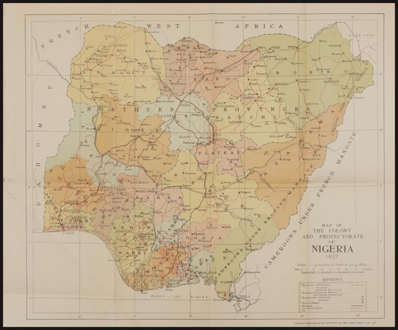
NIGERIA: 1937 multicoloured map (420x510mm) published by the Land & Survey Dept, Lagos showing provincial boundaries, roads & railways and government headquarters, folded as issued, small repaired tear & diagonal crease at lower-left. (Image1)
Estimate AU$100
Opening AU$ 75.00
Sold...AU$ 75.00
Closed..Nov-11-2022, 18:00:00 EST
Sold For 75
Sale No: 249
Lot No: 3635
Symbol: D
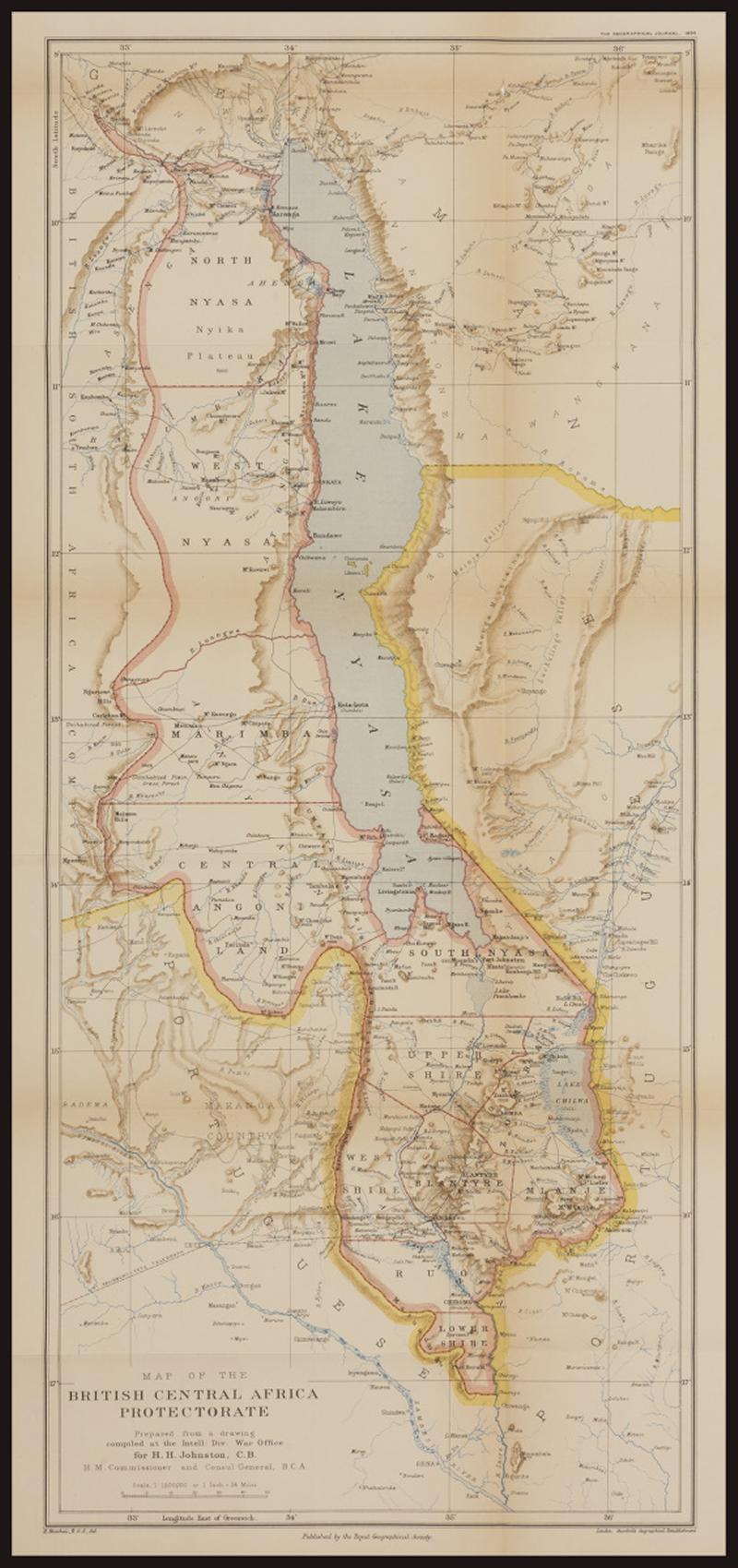
NYASALAND: 1895 multi-coloured map (765x345mm) of the 'British Central African Protectorate' published by the Royal Geographical Society and printed by Stanford's Geographical Establishment, London showing also parts of the surrounding areas under the control of the British South Africa Company (Rhodesia), Portugal & Germany, includes district boundaries and roads as well as the Fort Salidsury via Tete telegraph line coming into Blantyre, folded as issued, a couple of small closed tears in the folds otherwise very fine. [In 1907 the British Central African Protectorate was renamed Nyasaland, now Malawi] (Image1)
Estimate AU$200
Opening AU$ 150.00
Sold...AU$ 150.00
Closed..Nov-11-2022, 18:00:00 EST
Sold For 150
Sale No: 249
Lot No: 3636
Symbol: D
PALESTINE: 1932 black, red & blue sketch map (505x325mm) from the 'Survey of Palestine, Jaffa, 1932' printed by Waterlow & Sons, London & Dunstable including a large part of Transjordan as well as surrounding Syria and Sinai with an inset map to the Gulf of Aqaba, showing international & district boundaries, railways & roads, sand dunes & marsh, folded as issued otherwise very fine condition. (Image1)
Estimate AU$100
Opening AU$ 75.00
Sold...AU$ 75.00
Closed..Nov-11-2022, 18:00:00 EST
Sold For 75
Sale No: 249
Lot No: 3637
Symbol: D
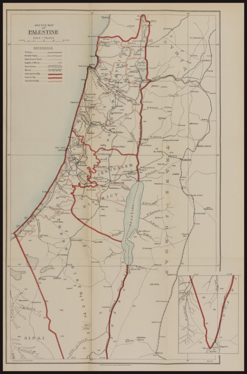
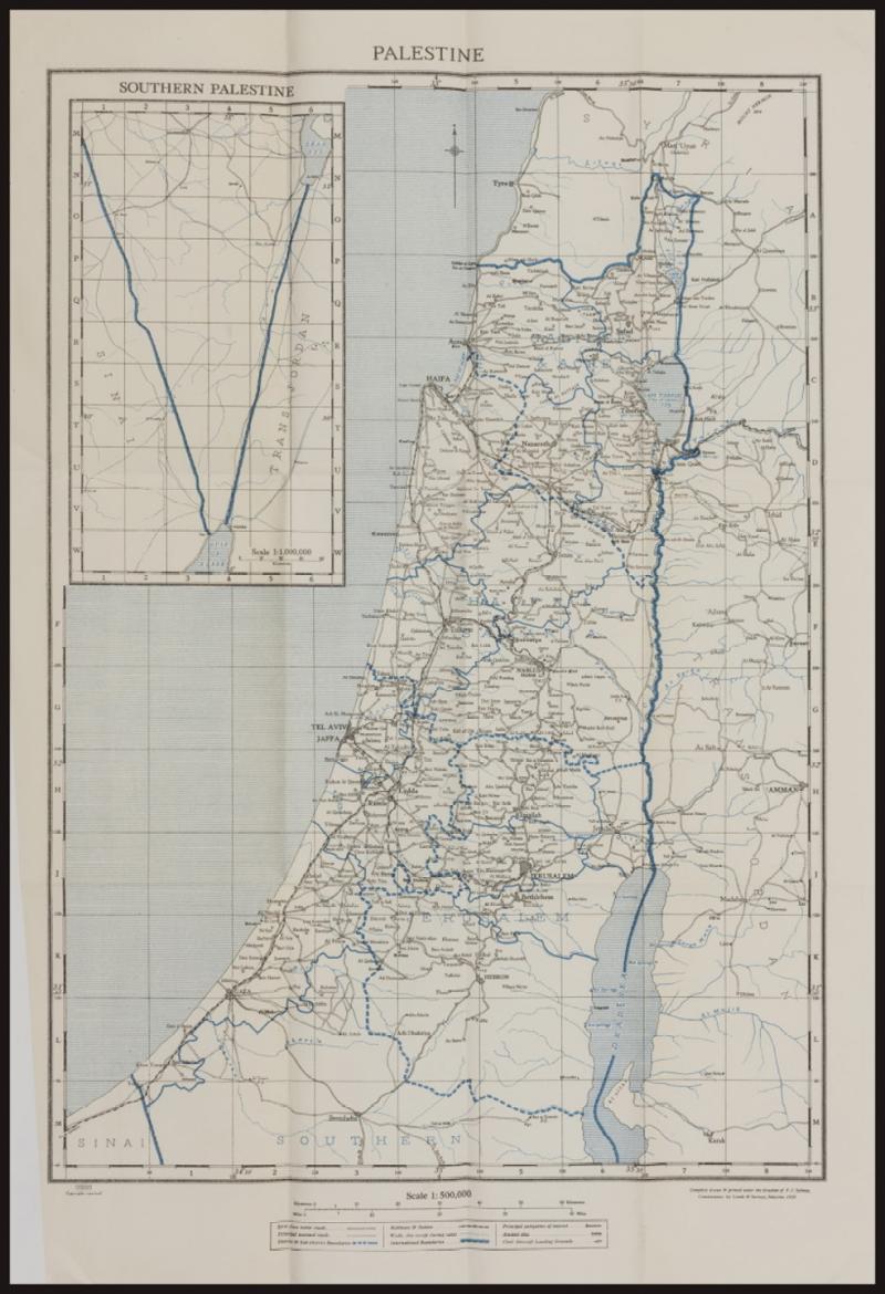
PALESTINE: 1937 black & blue map (618x410mm) 'Compiled, drawn & printed under the direction of FJ Salmon, Commissioner for Lands & Surveys, Palestine' including a large part of Transjordan as well as surrounding Syria and Sinai with an inset map to the Gulf of Aqaba, showing international & district boundaries, railways & stations, roads, wadis, principal antiquities & ancient sites as well as civil aircraft landing grounds, folded as issued otherwise very fine condition. (Image1)
Estimate AU$100
Opening AU$ 75.00
Sold...AU$ 75.00
Closed..Nov-11-2022, 18:00:00 EST
Sold For 75
Sale No: 249
Lot No: 3638
Symbol: D
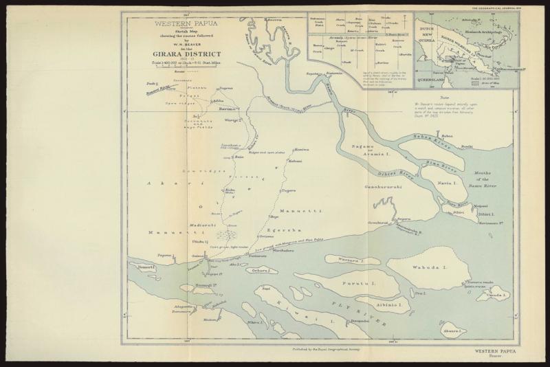
PAPUA: 1914 black, light blue & white map of Western Papua (240x360mm) published by the Royal Geographical Society 'showing the routes followed by WN Beaver in the Girara District 1910-13' between Domori Island in the west, Aworra in the north, Diribi Island in the east, and Kiwai Island in the south with an inset map of the region with the mapped area highlighted, folded as issued, a couple of very minor bends. [Wilfred N Beaver was a resident magistrate in Western Papua who explored the mainland up to the Dutch New Guinea boundary and certain regions east of the Fly River] (Image1)
Estimate AU$200
Opening AU$ 150.00
Sold...AU$ 150.00
Closed..Nov-11-2022, 18:00:00 EST
Sold For 150
Sale No: 249
Lot No: 3639
Symbol: D
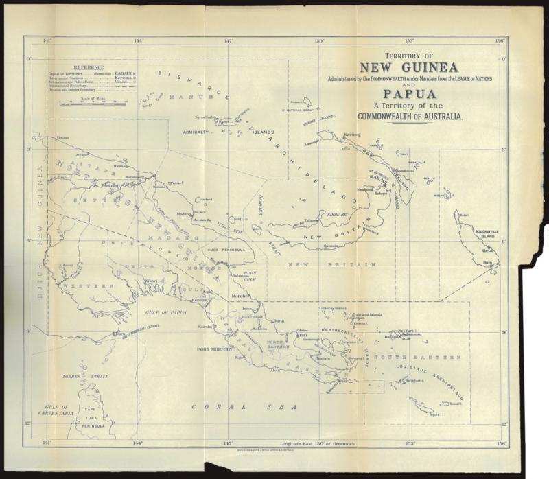
PAPUA: 1930s (circa) black & white map (323x355mm) printed by Waterlow & Sons Limited, London & Dunstable from the border with Dutch New Guinea in the west, the Bismarck Archipeligo in the north, Bougainville Island in the east, and Torres Strait Islands in the south, includes government stations, sub-stations, police posts, divisional & district boundaries, folded as issued. [The printer's inscription, without 'Watford', dates the map to the early 1930s; Watford operations were closed in 1928, after the Bank of England took over printing banknotes which had until then been printed by Waterlow under contract to the Treasury] (Image1)
Estimate AU$150
Opening AU$ 115.00
Sold...AU$ 115.00
Closed..Nov-11-2022, 18:00:00 EST
Sold For 115
Sale No: 249
Lot No: 3640
Symbol: D
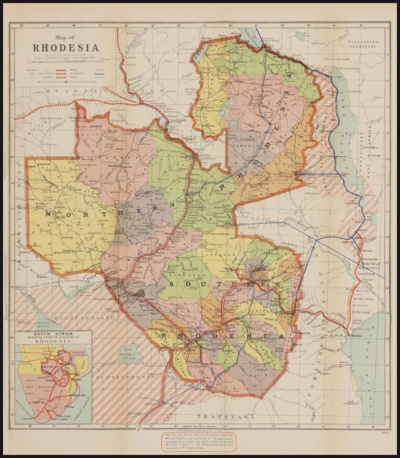
RHODESIA: 1923 multi-coloured map (480x425mm) printed by Waterlow & Sons, London showing Northern Rhodesia (now Zambia) and Southern Rhodesia (now Zimbabwe) as well as Nyasaland Protectorate (now Malawi) and adjacent parts of Portuguese East (Angola) & West (Mozambique) Africa, Belgian Congo, Tanganyika, Transvaal & Bechuanaland, includes railways, mines, telegraph lines & roads, with note at base 'The British South Africa Company owns the Mineral Rights over the whole of Rhodesia and concessions covering very large Land and Mineral Rights in the Bechuanaland and Nyasaland Protectorates', folded as issued, a couple of insignificant blemishes in the margins only. (Image1)
Estimate AU$100
Opening AU$ 75.00
Sold...AU$ 75.00
Closed..Nov-11-2022, 18:00:00 EST
Sold For 75
Sale No: 249
Lot No: 3641
Symbol: D
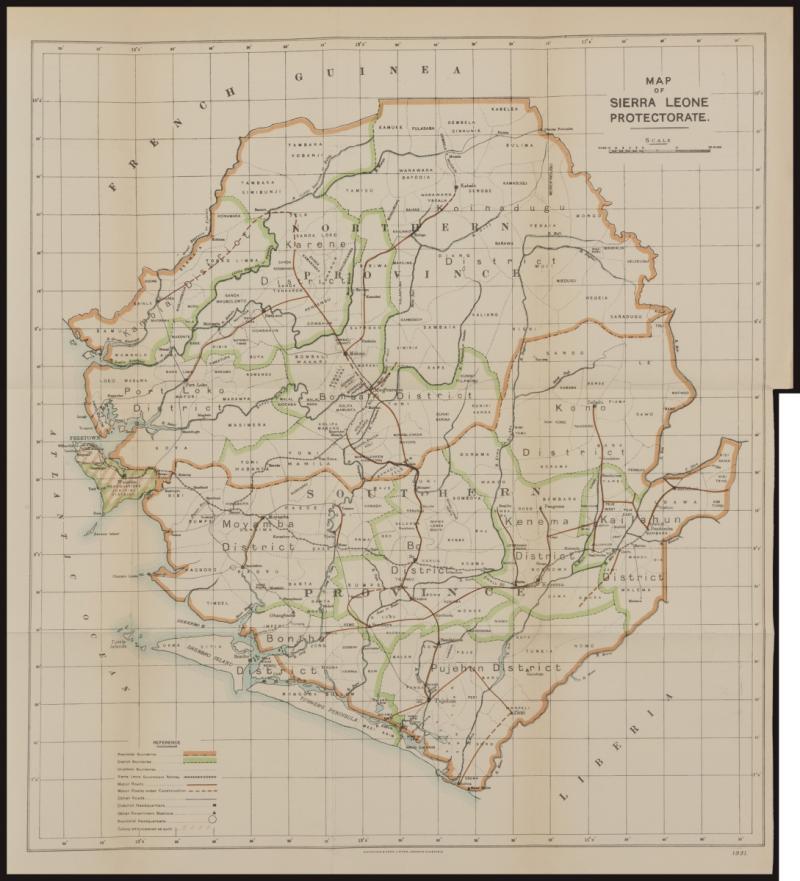
SIERRA LEONE: 1931 multicoloured map (420x370mm) printed by Waterlow & Sons, London & Dunstable showing provincial & district boundaries, roads & railways and district headquarters & government stations, folded as issued, very fine condition. (Image1)
Estimate AU$100
Opening AU$ 75.00
Sold...AU$ 75.00
Closed..Nov-11-2022, 18:00:00 EST
Sold For 75
Sale No: 249
Lot No: 3642
Symbol: D
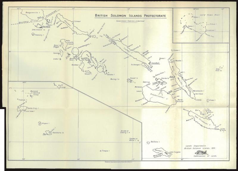
SOLOMON ISLANDS: 1925 black & white map (311x428mm) published by SGC Knibbs, Commissioner of Lands, Lands Department, British Solomon Islands and printed by Waterlow & Sons, London, Dunstable & Watford showing the area from Bougainville Island (New Guinea) in the north-west to San Cristoval Island in the south-east with inset maps of Santa Cruz & Vanikoro Islands to the south-west and Lord Howe Atoll to the north-east, folded as issued. (Image1)
Estimate AU$100
Opening AU$ 75.00
Sold...AU$ 75.00
Closed..Nov-11-2022, 18:00:00 EST
Sold For 75
Sale No: 249
Lot No: 3643
Symbol: D
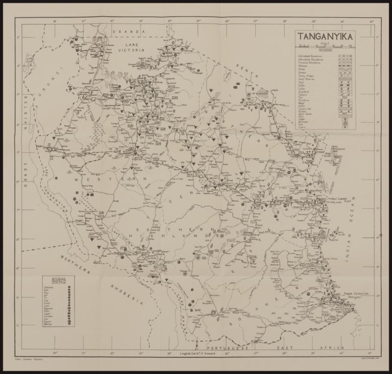
TANGANYIKA: 1920 (circa) black & white sketch map (405x430mm) including small parts of surrounding Northern Rhodesia, Belgian Congo, Urundi, Uganda, Kenya, Zanzibar & Portuguese East Africa, showing international, colonial & provincial boundaries, roads & railways, as well as detailed information on agricultural production & mining, folded as issued, very fine condition. [German East Africa was occupied by British & Belgian troops in 1916 and mandated to Britain as the Tanganyika Territory in 1920; Urundi was incorporated into the Belgian Mandated Territory of Ruanda-Urundi in 1924] (Image1)
Estimate AU$100
Opening AU$ 75.00
Sold...AU$ 75.00
Closed..Nov-11-2022, 18:00:00 EST
Sold For 75
Sale No: 249
Lot No: 3644
Symbol: D
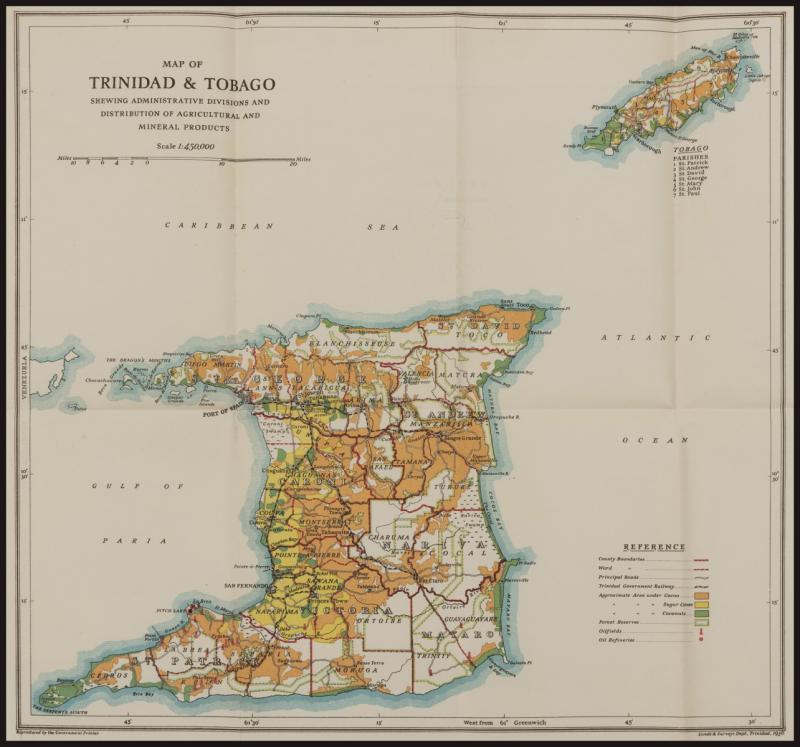
TRINIDAD & TOBAGO: 1936 multicoloured map (365x393mm) published by the Land & Survey Dept, Trinidad showing ward boundaries, roads & railways, the production of cocoa, sugar cane & coconuts and oil fields & oil refineries, folded as issued, very fine condition. (Image1)
Estimate AU$100
Opening AU$ 75.00
Sold...AU$ 75.00
Closed..Nov-11-2022, 18:00:00 EST
Sold For 75
Sale No: 249
Lot No: 3645
Symbol: D
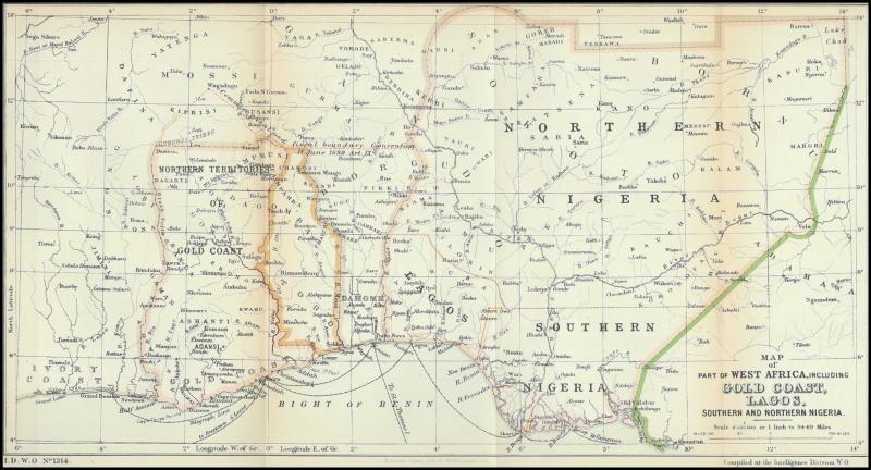
WEST AFRICA: 1905 (circa) black & white map (210x400mm) of 'Part of West Africa including Gold Coast, Lagos, Southern and Northern Nigeria' compiled by the Intelligence Division WO including also the French territories of Dahomey and part of the Ivory Coast, boundaries in pink, green & brown, major roads, rivers & shipping connections, folded as issued with a couple of minor blemishes in the margins otherwise very fine. [This map shows separate Colony of Lagos that was absorbed into Southern Nigeria on 1.5.1906] (Image1)